
By Richard W. White, Head of Research & Development, LightBox
At last month’s Environmental Bankers Association conference, I sat in on a session titled Environmental Detectives that delivered exactly what the name promised. Unexpected clues hiding in plain sight.
Midway through the presentation, Hope Cline, National Client Manager at AEI Consultants, pulled up a slide highlighting abandoned airfields across the U.S. and referenced a little-known website: Airfields-Freeman.com.
I pulled out my phone to snap a picture and glanced around the room. Nearly everyone else was doing the same.
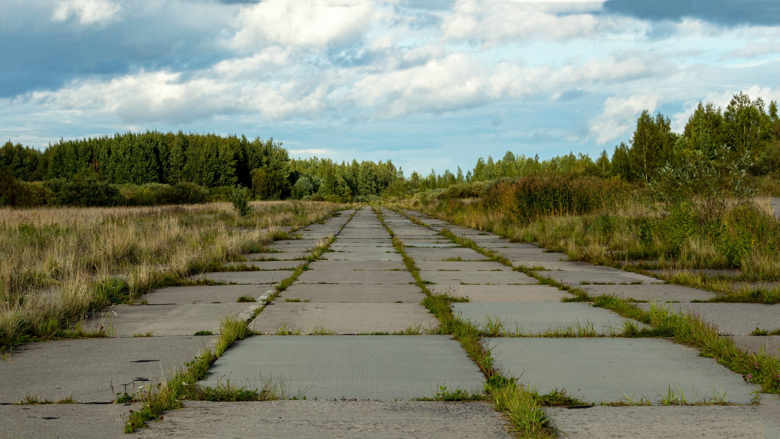
The site documents more than 2,800 abandoned and largely forgotten airfields across all 50 states, Washington, D.C., and Puerto Rico. Many have disappeared from modern maps and environmental datasets entirely.
For most, it was a fascinating piece of aviation history.
For environmental professionals, it highlighted a gap in how historical land use is captured in environmental data.
A Blind Spot in Plain Sight
Historic airfields can indicate past land uses tied to fuel storage, maintenance operations, and disposal practices that predate modern regulations.
Many of these sites do not appear in standard environmental datasets.
They may be visible in historical aerial imagery or topographic maps, but older and closed airfields are not consistently captured as structured data. That gap can lead to incomplete site histories during due diligence.
That gap is what caught the room’s attention.
“Seeing the reaction in the room was telling,” said Cline. “I have long thought it was an under-utilized resource, and seeing everyone jot it down was a reminder. It reinforced how valuable these kinds of historical datasets are and how much more useful they become when they are integrated into the tools people already use every day.”
What happened next unfolded quickly.
Within minutes, I reached out to our product and data acquisition teams. Before the session had ended, we were in touch with the site’s author and had already begun exploring how to bring the dataset into LightBox Live.
That initial connection led to a collaboration. A donation was made to support the continued maintenance of Airfields-Freeman.com. Permission was granted to integrate the dataset into the LightBox platform with full attribution and direct links back to the original site.
We recognized immediately how unique and valuable this dataset was. Our goal was to make it accessible within existing environmental workflows so teams can identify potential risks without additional manual research.
Mapping Hidden Land Use to Strengthen Environmental Due Diligence
Today, not even a month later, more than 2,800 historical airfields are integrated into the LightBox environmental database and will be updated quarterly.
They are:
- Spatially available within LightBox Live and Radius Map Reports
- Referenced directly within environmental reports, with links back to Airfields-Freeman.com
- Connected to workflows used by environmental consultants, lenders, and risk professionals
This creates a clearer view of historical land use, particularly where aviation-related activity may not be immediately visible.
From Planned Runways to Redeveloped Land
The dataset surfaces connections between well-known places and overlooked land use history, including several tied to Walt Disney World.
One example is the Epcot Center Ultralight Flightpark, which operated in the 1980s and early 1990s as part of aerial demonstrations within the park. The site supported active flight operations before being closed and redeveloped into what is now part of a Disney resort property.
Other entries point to plans that never fully materialized. Early concepts for EPCOT included an “Airport of Tomorrow,” with designs showing four 7,000-foot runways, along with supporting aviation infrastructure. These plans were ultimately scaled back and never built. This aviation history is not visible on the ground today.
The dataset also surfaces sites tied to well-known aviation figures and operators. One of the clearest examples is Roosevelt Field in Garden City, Long Island, where both Charles Lindbergh (1927) and Amelia Earhart (1932) took off for their first solo, non-stop transatlantic flights.
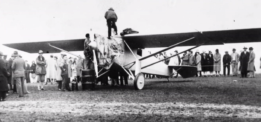
Source: A photo from Airfields-Freeman.com of the preparation of Charles Lindbergh’s Ryan “Spirit of St. Louis” for his historic departure from Roosevelt Field for the world’s first solo transatlantic flight.
The site is also connected to pioneers such as Curtiss and Sikorsky, along with Howard Hughes, Goodyear Blimp operations, and Army training activity. Today, the site is Roosevelt Field Mall. In LightBox’s historical aerials, the airfield is visible in 1938, 1947, 1951, and 1953. By 1962, the mall is in place, and the topo map shows the airfield has disappeared by 1954.
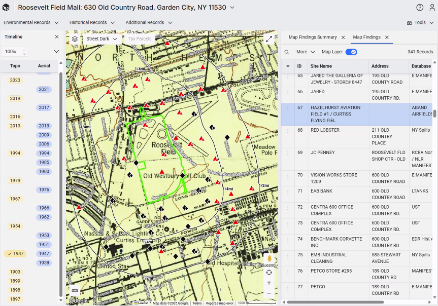
Source: LightBox Live shows the site of the former abandoned airfield at Roosevelt Airfield on Long Island, where Charles Lindbergh took off for his first solo, non-stop transatlantic flight to Paris.
For environmental professionals, these are indicators of prior land use that may not be reflected in standard environmental datasets. They provide additional context for how a site may have been used over time, particularly in cases where aviation-related activity is no longer apparent.
As transaction activity increases and properties continue to change hands, the need for complete site history remains critical.
The challenge is identifying what may not be immediately visible.
Datasets like this bring additional clarity. They surface prior land uses, support more thorough site evaluations, and strengthen decision-making.
“It was exciting to see how quickly this moved from a conference discussion to something integrated into the LightBox platform,” said Cline. “I’m glad this collaboration with Airfields-Freeman.com came together. Having this resource integrated helps us all make more informed decisions that protect our clients, human health, and the environment.”
Moments like that are a reminder of how much valuable data is still waiting to be uncovered. We are always on the hunt for new data that can help uncover risks and insights that might otherwise be missed.