Here’s why ALTA land surveys are critical to most property transactions.
- ALTA Land Surveys are required by most lenders and title companies due to their level of detail and accuracy.
- ALTA Surveys are the gold standard for meeting land title requirements.
- ALTA Land Title Surveys are used throughout the property transaction cycle to verify parcel location, encroachments, and other parameters that impact zoning and property ownership.
What is an ALTA Survey?
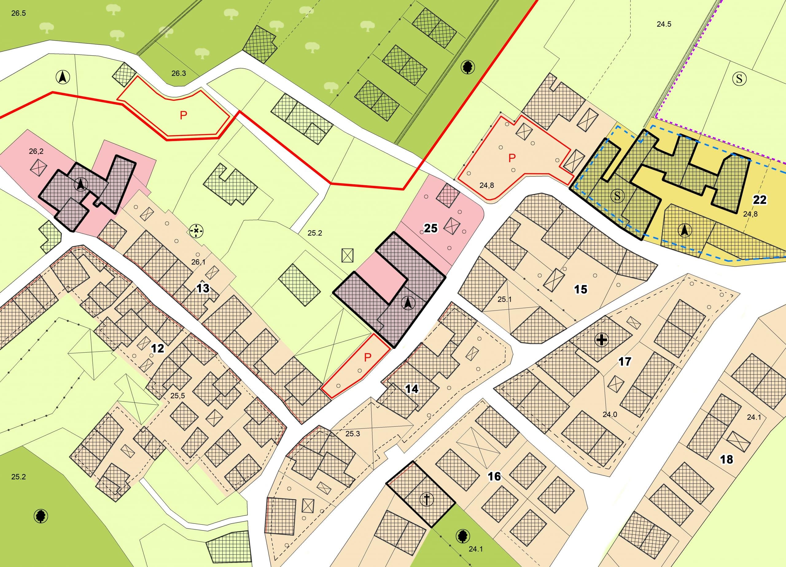
An ALTA survey is a specialized property survey that is considered the most comprehensive in the industry in detailing land parcel conditions. By identifying parcel boundaries, easements, setbacks or previously unrecorded fences or other structures, this survey provides details that can impact a commercial property’s value and development potential.
ALTA Land Surveys are critical to the due diligence process
An ALTA Land Survey is a critical part of the due diligence process for a property purchase or refinancing. It can be instrumental in mitigating risk for property buyers and helping resolve property disputes.
The survey, prepared by a licensed surveyor, follows the standards developed by the American Land Title Association (ALTA) and the National Society of Professional Surveyors (NSPS), two highly regarded industry organizations. Given the ALTA survey’s level of detail, it is required by most title companies and lenders during the due diligence stage of a property transaction. It is also included in many zoning reports to substantiate property conditions and characteristics.
ALTA surveys are used to evaluate properties and identify inconsistencies
A closer look at ALTA land surveys shows they provide all the critical details on a parcel, including the presence of any easements, encroachments, setbacks, and site improvements which might impact a property transaction. This level of detail allows a title company or lender to thoroughly evaluate the property for any inconsistencies or potential risks to a property buyer.
The survey might discover a utility easement or a side yard setback, for example, which would impact development on the site. An easement grants an entity, often a utility company or municipality, the right to access land for repairs or other activity without owning it. A landowner might not be allowed to build a new structure in that easement, impacting construction plans and possibly the property’s value. A setback is a portion of the property, measured from the lot line, where development is prohibited. An ALTA land survey could also reveal property encroachments, such as fences or other improvements, which might lead to lot boundary disputes. Discovering those items could prompt a property owner to rethink the transaction or renegotiate the project.
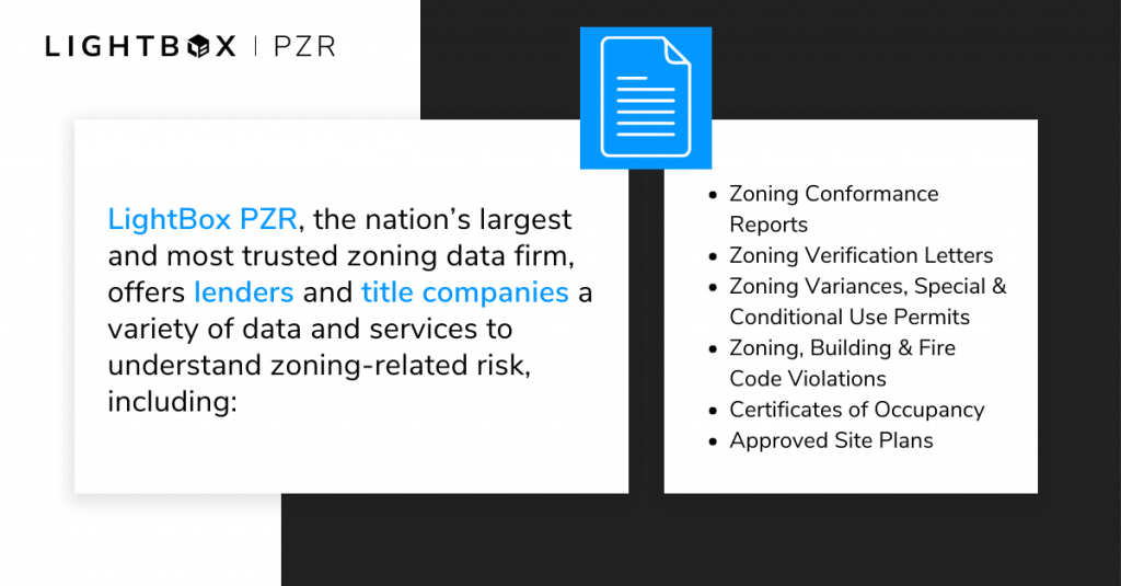
The ALTA Land Survey is also an important part of the zoning compliance process, as it is often the source in a zoning compliance report known as a PZR Report® for outlining details of property zoning. This occurs as a property transaction is reviewed and evaluated for zoning compliance. The PZR Report provides the reviewer with site information needed to perform a zoning review without on-site visits. It also details the property setback, height of the structure and number of parking spaces. These items are reviewed and confirmed on the PZR Report during the due diligence process. They are typically reviewed to obtain a 3.1 zoning endorsement of a completed structure by a title company.
- Steps involved in ALTA surveys
- An ALTA land title survey combines a property boundary survey, a location survey and a title survey. The surveyor examines both public and private land records, and then a physical analysis of the property and its boundary lines is conducted by a field crew. An ALTA title survey can take two to three weeks or longer, depending on site complexities and other factors.
- An ALTA land title survey combines a property boundary survey, a location survey and a title survey. The surveyor examines both public and private land records, and then a physical analysis of the property and its boundary lines is conducted by a field crew. An ALTA title survey can take two to three weeks or longer, depending on site complexities and other factors.
ALTA surveys protect property owners’ interests and mitigate risk
The ALTA survey has become a critical component of most real estate transactions due to its ability to help protect property owners’ interests and mitigate risk. Founded in 1907, the national trade association represents more than 6,000 title insurance agents, abstracters and underwriters across the United States who search, review and ensure land titles for those who invest in real estate.
As a title company is evaluating whether to commit to issuing title insurance on a property, it will focus on the ALTA land survey as a critical underwriting tool during the due diligence stage. The survey ensures that a subject property complies with its land use and the stated building area and floor space allocation.
The most comprehensive land survey in the industry
ALTA land title surveys are the most comprehensive surveys used in property transactions as they show each property element, including location, lot configuration, improvements, easements and other defining factors. These surveys go above and beyond most public records searches to provide the critical property information required by many lenders and title companies to evaluate whether to approve the loan and provide title for a real estate transaction.
- ALTA survey requirements
- ALTA surveys are conducted using specific requirements which define survey and measurement standards, how plans or maps are prepared and other factors. The survey process involves four areas: research, fieldwork, drafting and revision. The fieldwork stage includes identifying boundary lines and markets and can be the most challenging and time-consuming portion. After all those details are gathered, surveyors prepare an analysis of the data and create a survey map that includes all the details. The survey is then reviewed and revised as needed to account for any new information, such as parking spaces, site access points, and nearby active construction sites. Evidence of any easements would be disclosed, as well as nearby burial grounds, water features or other factors which define the property or its adjacent areas. The ALTA survey requirements were updated in 2016 to allow zoning information to be included by other industry professionals not involved in the surveying process.
ALTA surveys are necessary in several common scenarios to help identify property details
ALTA land title surveys are used in multiple scenarios to help identify important property details and mitigate risk, including:
- Title survey for Insurance purposes
- The ALTA title survey adheres to the strict ALTA standards, which assures title insurance companies, lenders and other interested parties which all title elements are reviewed and identified. This is a critical step for buyers, sellers and owners to obtain comprehensive title insurance for any property.
- The ALTA title survey adheres to the strict ALTA standards, which assures title insurance companies, lenders and other interested parties which all title elements are reviewed and identified. This is a critical step for buyers, sellers and owners to obtain comprehensive title insurance for any property.
- Buying or selling commercial real estate or vacant land
- An ALTA survey is an important due diligence tool for commercial property buyers. The value of an improved land parcel can be notably impacted by details identified in the survey, most of which are not found in public records or previous due diligence reports. Buyers are provided the details to resolve property disagreements with the seller. Property sellers also use ALTA surveys as a comparison against a buyer’s survey.
- An ALTA survey is an important due diligence tool for commercial property buyers. The value of an improved land parcel can be notably impacted by details identified in the survey, most of which are not found in public records or previous due diligence reports. Buyers are provided the details to resolve property disagreements with the seller. Property sellers also use ALTA surveys as a comparison against a buyer’s survey.
- Buying a piece of vacant land
- Buying vacant land is sometimes less complex than buying improved property, but there are nuances to those transactions that make ALTA surveys particularly helpful. Many vacant parcels have never been surveyed or were surveyed many years ago when surveying techniques were not as detailed or accurate. This can create risks for a buyer regarding boundaries, encroachments and ownership issues, which have never been documented or were incorrectly recorded. An ALTA survey is an important risk mitigation tool which can give buyers peace of mind before buying vacant land.
Learn more about LightBox Zoning and Environmental Due Diligence
As a trusted leading provider of data and technology, LightBox is a critical source for zoning and environmental due diligence to empower strong decision-making. Gold standard PZR Reports and industry-leading EDR environmental due diligence data often intersect with ALTA surveys to help identify specific property risks, support zoning compliance and create efficient and connected workflow solutions for our clients. Learn more about our PZR reports and subscribe to our emails for the latest industry news.