
EXPANDING BROADBAND SERVICE TO UNSERVED AREAS REQUIRES ACCURATE, RELIABLE DATA—AND SURVEYS ALONE CAN’T PROVIDE IT
States governments across the country are seeking to expand broadband service to underserved areas by tapping into more than $100 billion in federal funds tied to Covid relief, the American Rescue Plan Act, and the recent Infrastructure Investment Act. But inaccurate FCC broadband maps originally created based purely on census blocks are hampering progress in bridging the broadband divide. This challenge has created demand for maps that better reflect what unique communities within individual states truly need. “Funding decisions by census blocks means many households remain unserved, and as we look across different neighborhoods, the quality of network performance differs by neighborhood and demographics,” says Brian Darr of Ookla, a mobile and broadband network intelligence, testing applications, and technology company.
To create broadband maps, states officials often begin with surveys to determine which areas need broadband service—but there are serious limitations with this approach. States may need to keep surveys open for a long period of time to draw an appropriate number of responses or may not have a large enough marketing budget to reach a wide range of constituents. If only a narrow demographic segment responds, the state may end up with an unbalanced view of what it needs to accomplish. A survey Kansas released last year received only “a patchwork of responses,” according to an official, who added, “It’s hard to make good policy with bad data. Our goal is to get accurate data so informed decisions can be made on where to make investments.”
Surveys are only able to paint a general and incomplete and inaccurate picture. If the sample size from a survey is large enough, officials can derive patterns and an overall sense of where the public stands, but in general these estimates aren’t precise, and the results can be misleading if more accurate methods of information collection aren’t used. In rural America, where most of the unserved broadband areas are located, survey participation rates are low and aren’t of much value for developing precise broadband maps. States need more accurate, granular data to create broadband maps that reflect the needs of their citizens, down to those living in the smallest parcel in the farthest corner of the state.
LightBox’s SmartFabric Drills Deeper Than Surveys to Deliver Accurate Mapping Data
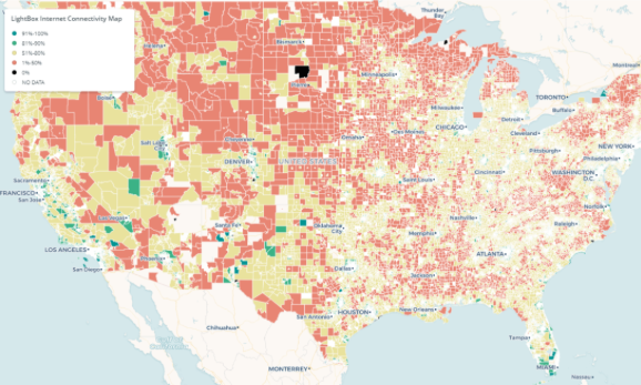
“Reliable data is essential for broadband planning—all stakeholders need good mapping software and the ability to understand a project’s financial returns,” says Jeffrey Zern of Windstream, an Arkansas-based telecommunications company. LightBox recognizes that accurate and granular maps—based upon precise location data, serviceability, and analytics—are required for government investment to be targeted and rapidly deployed to communities in need. We have helped states, including Georgia and Montana, successfully develop broadband maps. Georgia was able to create a robust policy framework for identifying more than 400,000 additional unserved locations that other broadband map providers were unable to identify.
LightBox’s geospatial mapping software SmartFabric layers the location of approximately two billion Wi-Fi access points on top of LightBox’s national Broadband Serviceable Location Fabric, which details the precise geospatial extent, address(es), occupancy classification, and number of business or dwelling units for structures across the U.S. Through its granular location fabric and geospatial expertise, LightBox has developed the necessary foundation to states to create viable broadband availability maps that greatly augment the information available from surveys.
SmartFabric offers a wide range of powerful features:
- It identifies actual internet connectivity instead of serviceability. We pinpointed locations that have active internet, as opposed to locations that could be served by a service provider upon request. This is an important distinction because it helps differentiate lack of service due to infrastructure limitations versus other barriers to adoption.
- It shows presence of internet versus broadband-speed internet. While the national debate is centered around broadband-quality internet, LightBox can discern the availability of various speeds when creating the broadband availability map.
- Maps are built from the structure up. LightBox aggregated broadband service at every identifiable location in the country, linking each structure to property-level connectivity and related metrics.
LightBox SmartFabric is the next generation of LightBox’s SmartParcels, a nationwide parcel-based location fabric that connects parcel boundaries with more than 300 property and tax attributes, spatially enabling the property data. SmartParcels is currently licensed by many federal and state agencies. Broadband mapping projects in Georgia and Alabama leverage LightBox SmartParcel location fabric.
Broadband related surveys have been carried out for more than a decade at the federal, state, and local levels, and in the commercial sector, a trend that will continue. They provide one piece of the puzzle, but without other pieces the entire picture isn’t clear. If you were planning a trip, would you rely on a mental picture of where you’re going and wing it, or go with a precise and accurate map? States across the country are increasingly choosing the latter for their broadband expansion efforts—and LightBox is poised to help them succeed.